Valle de la Luna - Moon Valley and Sunset in the Atacama Desert, Chile - interactive 360-degree video
If you are viewing this on a mobile device, please turn to LANDSCAPE position. Drag the view on the screen with your finger (or move the device around) and you will see everything all around you – even what’s behind or on the ground. Viewing on a PC? Use the mouse to drag the view anywhere you want to see. If you have a VR viewer (goggles) you will be fully immersed. Better than IMAX! SUGGESTION: see the video again, change the viewing angles. You will discover new things!
IMPORTANT! Please click on the "Watch on YouTube" link for best viewing. The embedded small screen is inadequate for interactive 360 degree videos.
To see the same video in conventional screen format (non 360-degree video)
click here
360 preference survey
- If you’d like to research or purchase a 360-degree camera, here’s a link to a 360-degree camera like the one I used to produce my videos. I have nothing but good things to say about my camera (which I purchased from the same website as the link above).
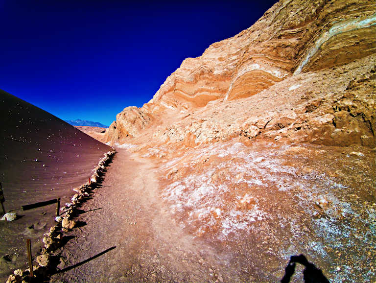
What’s it like to actually walk in Valle de la Luna?
- As you came here to find out “what’s it like to visit Valle de la Luna” in the Atacama desert, let’s jump right into it with some essential information.
- Caution! Depending on your general physical conditioning, please keep in mind the following:
- 1. This area is located at 2,500 meters (8,200 feet) above sea level. It may be OK for a first day visit when you arrive in Atacama, but probably it would be better to save it for a day two visit.
- 2. There are areas where you will walk in soft sand. Walking in soft sand at 2,500 meters altitude may be easier for some than others.
- 3. There will be an uphill portion, to get to the top of a dune. Walking uphill, in soft sand, at 2,500 meters altitude may be easier for some than others.
- 4. If you go in the summer, in full sunlight, it may be hot. Summer temperatures can reach 40 degrees Celsius (104 degrees Fahrenheit). Walking in hot weather, uphill, in soft sand, at 2,500 meters altitude may be easier for some than others.
- That is the reason why the walking portion of this visit is short. (It is also as exciting as any walk in the desert can be…). If you are fit, you will find that the walk is too short. Others may have trouble reaching the top of the dune. I don’t think you could do any better by visiting on your own, without a tour group, as this area is a National Park and you can only walk on vary narrowly designated paths. If you like biking, there is a bike path from San Pedro (I didn’t take it on this trip as I didn’t have a partner and was a bit skeptical about venturing into the Moon Valley alone…) That may give you a bit more freedom to explore, but the rules are strict and there are people everywhere watching every step you take.
Overview of Valle de la Luna
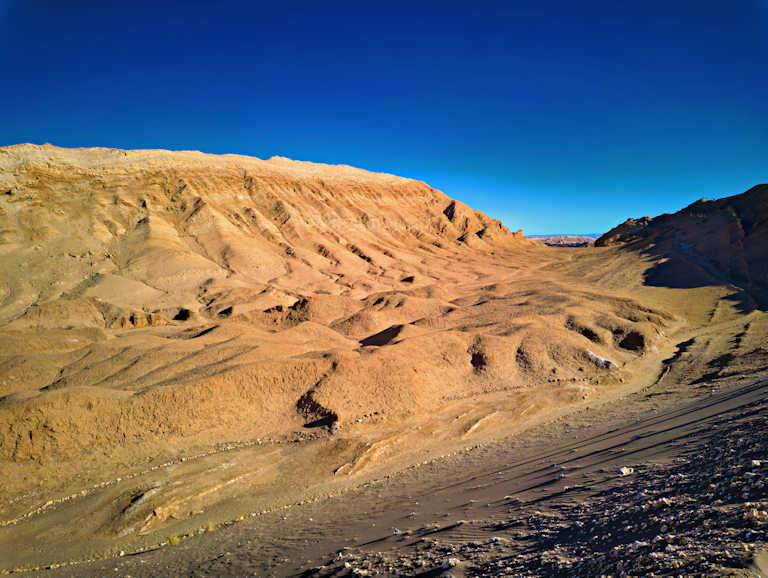
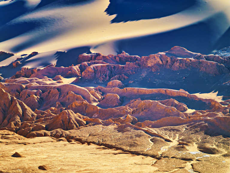
- The Valle de la Luna, or Valley of the Moon, is a stunning natural reserve located in the Cordillera de la Sal (Salt Mountain Range), near the town of San Pedro de Atacama in Northern Chile’s Antofagasta region. It is a part of the Los Flamencos National Reserve. Its name is derived from its surreal, sculpted landscape, which is often described as resembling the surface of the moon due to its dramatic rock and sand formations.
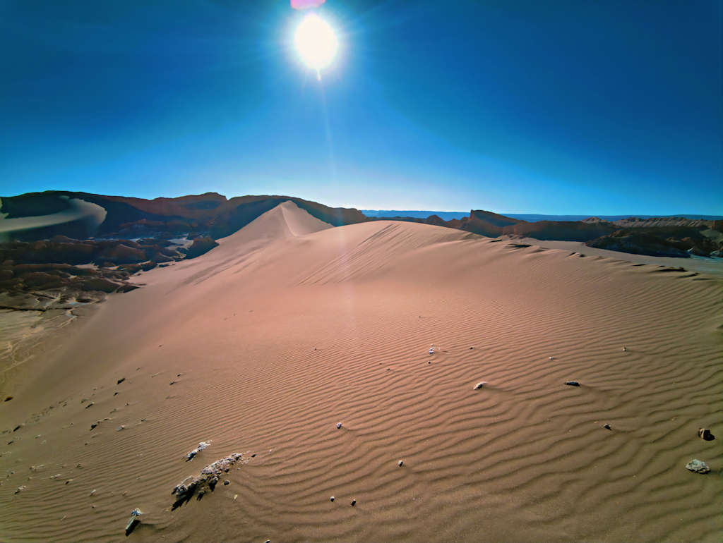
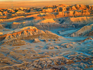
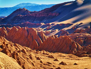
- The landscape is the result of millions of years of geological activity. It was originally an ancient salt lake bed that was lifted and folded by shifting tectonic plates. Subsequent erosion by wind and occasional water has sculpted the salt, gypsum, and clay into remarkable formations, including vast dunes, salt caves, and prominent landmarks such as the Las Tres Marías (The Three Marys) rock formation and the Great Dune. The contrasting colors—ochre rocks, white salt deposits, and blue sky—contribute to its unique, otherworldly appearance.
- Valle de la Luna (Moon Valley) receives virtually no yearly measurable precipitation.
Unique Features and Scientific Importance
- The region’s unique stratigraphy, salt formations, and evidence of ancient volcanic activity and water erosion provide a living laboratory for studying planetary geology and Earth’s history. The distinct formations, such as the Vilama Formation rocks, offer insights into the region’s long-term geological processes.
- Valle de la Luna (Moon Valley) is an otherworldly landscape which bears striking resemblance to the surface of the Moon. The environment’s extreme aridity and resemblance to the Martian surface have led to its use as an analog site for Mars exploration. Scientists, including those from NASA, have used the Atacama Desert to test prototype rovers and instruments for future missions to Mars, making it a crucial site for astrobiological and technological development.
- Valle de la Luna is a site that perfectly encapsulates the intersection of natural wonder, “tourist attraction” and scientific laboratory.
Human Presence and Settlements
- Valle de la Luna, situated within the remarkable Atacama Desert, has a rich tapestry woven from the threads of human activity throughout history. While the valley itself may appear desolate, evidence suggests that indigenous communities have long since inhabited the surrounding areas. The Atacama Desert has served as a vital resource for pre-Columbian civilizations. These indigenous peoples, including the Atacameños, have historically relied on the region’s unique resources, utilizing ancient knowledge to sustainably manage water and agriculture in harsh conditions.
- As urbanization swept across the region, these settlements gradually transformed, leading to the establishment of small towns such as San Pedro de Atacama. This growth has played a significant role in how the valley is perceived and accessed today. While Valle de la Luna remains largely uninhabited, tourism has surged in recent years, driven by its surreal landscapes that mimic the surfaces of the Moon. This packed influx of visitors has undeniably altered the dynamics within the valley, bringing both economic benefits and environmental challenges.

Visiting Valle de la Luna: Practical Information
- Distance from San Pedro de Atacama: The main entrance is approximately 13 km (8 miles) west of San Pedro de Atacama. It is accessible via paved and unpaved roads and can be reached by organized tour, rented car, or bicycle. The drive to the valley typically takes about 30 minutes by car, allowing visitors to enjoy the scenic landscape along the way.
- The entrance fee for the park is separate from any tour price and is typically around 6,000 Chilean Pesos (approx. $7 USD), although prices can vary, and payment is generally required at the entrance, sometimes in cash (Chilean money CLP).
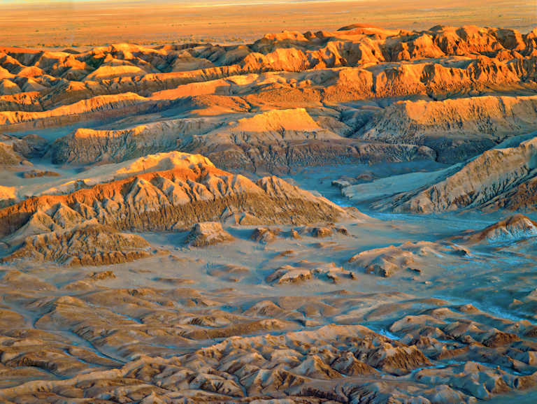
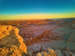
- Best Time to Visit: The valley is open year-round, but the most popular time to visit, and often recommended, is during the late afternoon to catch the sunset. The changing light transforms the landscape, creating a spectacular display of colors and shadows over the dramatic rock formations. While mornings offer a quieter experience, the sunset viewing from spots like the Mirador de Kari is a highlight for most travelers. You will see in the video that we stopped there, as well. The sunset colors of the desert surrounded by volcanic mountains in the distance are truly remarkable.
- To avoid the peak crowds of the austral winter (June–August), the shoulder seasons of April-May and September-December offer a good balance of mild temperatures and fewer visitors.
- The desert is extremely dry, and the sun is intense. It is crucial to bring copious amounts of water (at least 2 liters per person), wear sunscreen, sunglasses, and a hat. Wear comfortable, closed-toe walking or hiking shoes, as the terrain is uneven with sand and rocks.

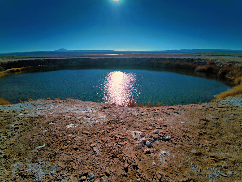
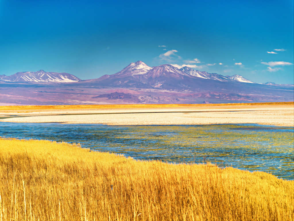
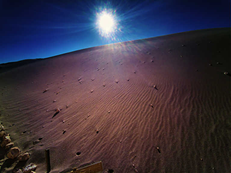
- Here are a few more images from Valle de le Luna (Moon Valley) and the sunset at Mirador de Kari.


Download full-size master image files
Please use our images!
Your purchase is important to us!
- The financial reward is important. The moral boost we receive when someone cares enough to click that “ADD TO CART” button: priceless! Thanks!
- You may use the downloaded images as wallpaper, in a slide show, or to supplement your collection of images from a location you care about. Other possible use cases: a research paper, newsletter or personal website.

- The size of our master photo files is no less than 7952 x 5304,.JPEG, with very light compression. The photos taken during a 360 degree shoot (featured on a blog page that includes a 360 degree video) are taken in RAW format, with a phone camera. The RAW file is “developed” and processed with advanced software, including increasing the resolution with AI and AI upscaling. The resulting large format file is then polished for its final creative look.
Conditions of use for downloaded images:
- Downloading an image at listed price does not provide ownership of the image (we retain copyright). It provides a license for limited use and distribution of the downloaded image.
- Distribution is limited to 50,000 exposures or copies and for projects with a total budget of $5,000 or less. No billboards or magazine covers.
- May be used only with attribution as follows:
-
- © Photography by Cristian Coban, visit
whatsitliketovisit.com
- Any image or video purchased or copied from our website may NOT be used for resale, download or redownload, distribution or redistribution, or any other further commercial use.
- We accommodate larger projects and distribution at industry competitive rates. Please Contact us with details of your project and we will be happy provide a quote.