Hanga Roa to Rano Kau crater - an Easter Island, Chile, hike - interactive 360-degree video
If you are viewing this on a mobile device, please turn to LANDSCAPE position. Drag the view on the screen with your finger (or move the device around) and you will see everything all around you – even what’s behind or on the ground. Viewing on a PC? Use the mouse to drag the view anywhere you want to see. If you have a VR viewer (goggles) you will be fully immersed. Better than IMAX! SUGGESTION: see the video again, change the viewing angles. You will discover new things!
IMPORTANT! Please click on the "Watch on YouTube" link for best viewing. The embedded small screen is inadequate for interactive 360 degree videos.
To see the same video in conventional screen format (non 360-degree video)
click here
360 preference survey
- If you’d like to research or purchase a 360-degree camera, here’s a link to a 360-degree camera like the one I used to produce my videos. I have nothing but good things to say about my camera (which I purchased from the same website as the link above).
Hanga Roa: The Heart of Easter Island (Rapa Nui)
- “Hanga Roa” means “wide bay” or “long bay” in the native Rapa Nui language. Hanga Roa serves as the main town, harbor, and administrative center of Easter Island (Rapa Nui), a special territory of Chile. Situated on the lowlands between the extinct volcanoes of Terevaka and Rano Kau, it is the home for the vast majority of the island’s inhabitants.
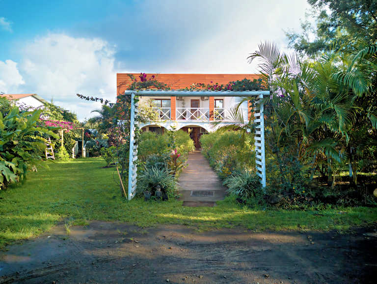
- I started the hike at a lovely guesthouse that served as my base for the week I spent on Easter Island. Here’s a picture:
Hanga Roa: A bit of history
- Most of the inhabitants of Easter Island live in Hanga Roa. It serves as the island’s cultural and economic hub. The original inhabitants of Easter Island were Polynesians, believed to have arrived from the Marquesas Islands or Mangareva. Local legends point to the chief Hotu Matu’a arriving on the island with his family in a large canoe. While there is uncertainty about the precise date of settlement, published literature suggests it occurred between 300–400 CE and 700–800 CE (recent studies push that range closer to 1000-1200 CE).
- The first recorded contact between the inhabitants of Easter Island (Rapa Nui) and European navigators occurred on April 5, 1722. The island was sighted and visited by the Dutch Admiral Jacob Roggeveen. Because Roggeveen’s crew spotted the island on Easter Sunday, he named it Paasch-Eyland, which means “Easter Island” in Dutch. He only spent one day on the island. It wasn’t until about 50 years later that the island was visited again. In 1770 the island was visited by a Spanish expedition led by Felipe González de Ahedo and in 1774 by British explorer James Cook.
- There are important methodological differences in studying the history and culture of Easter Island between pre-European contact times (pre 1722) and the era after first contact was made. As there was no formal indigenous writing system, our knowledge is limited to what we can infer from archeological remains, including petroglyphs, supplemented by what was transmitted by oral traditions, in the form of legends, songs, rituals, tales and such. The European explorers, fortunately, attempted to document everything they experienced in remarkable detail, in their expedition logs and through drawings. For example, Admiral Jacob Roggeveen one-day visit netted the following information: he reported seeing the inhabitants praying to the statues. He noted that people would kindle fire in front of the “remarkably tall stone figures,” squat down, and bow their heads. He described the statues as being “all hewn out of stone, and in the form of a man, with long ears, adorned on the head with a crown” (referring to the pukao, or red topknots). Roggeveen expressed wonder at the skill with which they were made. He mentioned that a clear, reserved space was set around these objects of worship by laying stones to a distance of twenty or thirty paces. These spaces are the ceremonial platforms known as ahu. Roggeveen noted that some men, whom he took to be priests, paid more reverence to the gods. These individuals could be distinguished by “wearing great white plugs in their ear lobes” and having their heads wholly shaven.
- As you see in my video, the vestiges of Moai and other stone sculptures are to be seen just about everywhere in Hanga Roa. That is also true for Easter Island in its entirety. There are about 887 documented monolithic statues. If counting unfinished or incomplete Moai, the number is closer to 1000. Other videos I have taken in this series will feature the Moai in Hanga Roa and other locations on Easter Island.
- Unfortunately, the contact with European visitors also meant receiving visits from slave traders and being exposed to different societal structures, trades and to diseases for which there was no local immunity. The native population declined and so did an entire social system that made possible the creation of the Moai.
- Hanga Roa’s population today stands at approximately 7,000 residents. The lifestyle here is intertwined with both the natural beauty of the island and the economic pursuits of fishing, artisanal crafts, and tourism. The local customs and values are embedded in the town’s architecture, festivals, and daily life. Notable cultural sites, including the Ahu Vai Uri and the Eva Eka site, provide glimpses into the island’s rich past and the unique identity of the Rapa Nui people.


Walking in Hanga Roa – a “situation” occurred
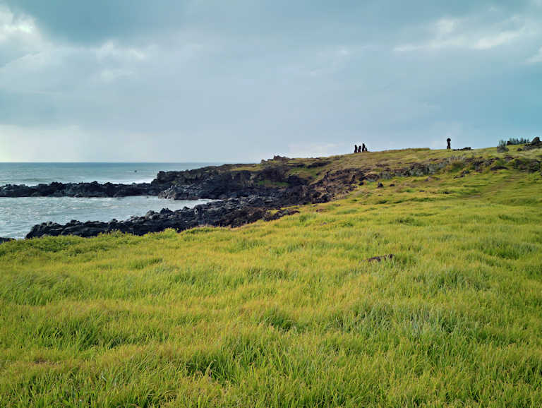
- My hike was divided in two segments. The first segment was walking from my guesthouse to the starting point of the Rano Kau crater hike. That starting point is located in the natural harbor of Hanga Roa, an area that is dotted with Moai and various other stone sculptures. From that starting point, I used a very common app with local hiking trails and followed the suggested trail.
- The map looked OK, taking me from the water’s edge in Hanga Roa to the Rano Kau crater’s edge. The trail began by taking a sort of a shortcut through some neighborhoods. That was great, as I would rather walk through small streets in local neighborhoods.
- At one point, the trail indicated entering, through a gate, someone’s yard. I proceeded a bit careful not to create a “situation”, but trusted that it is probably a shortcut trail that many take, on the principle of what we call “an easement”. After a while it became clear that the trail was leading straight to the house, into someone’s bedroom. Luckily for me, there was no ferocious dog in sight.
- I made a quick 180-degree turn and exited the property. After being back on the main road, the “situation” I almost got into, became comical. It appears that the trail was laid (and GPS’d) by someone that stayed at that house, in that bedroom, which probably has an exit on the other side of the house, saving 1 or 2 miles of walking around a local neighborhood.
- Feel free to comment below if you’ve ever had a similar situation.
- I made a note to myself to be careful in the future, if I lay out a new hiking trek and publish it online, NOT TO INCLUDE MY BEDROOM in the hike.
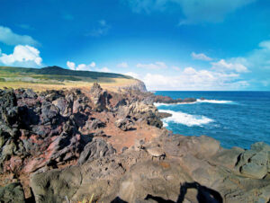
Rano Kau Crater: A Geological and Cultural Landmark
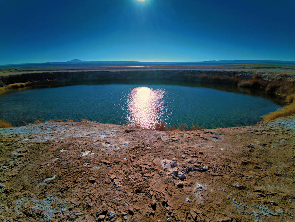
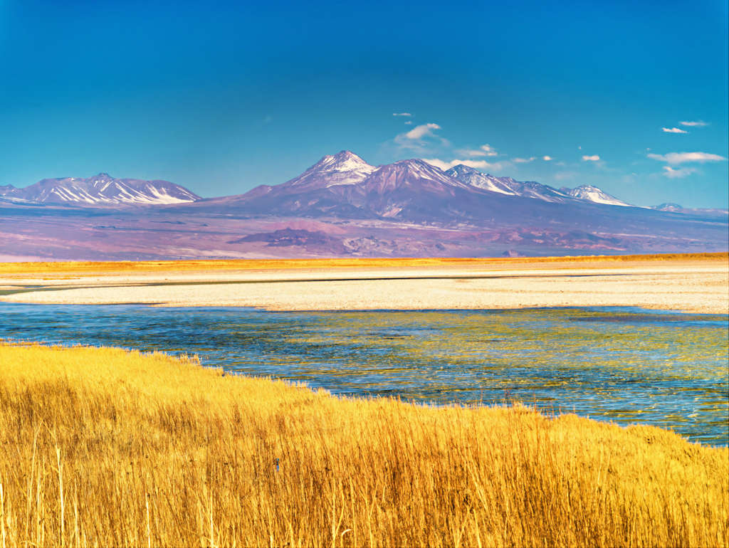
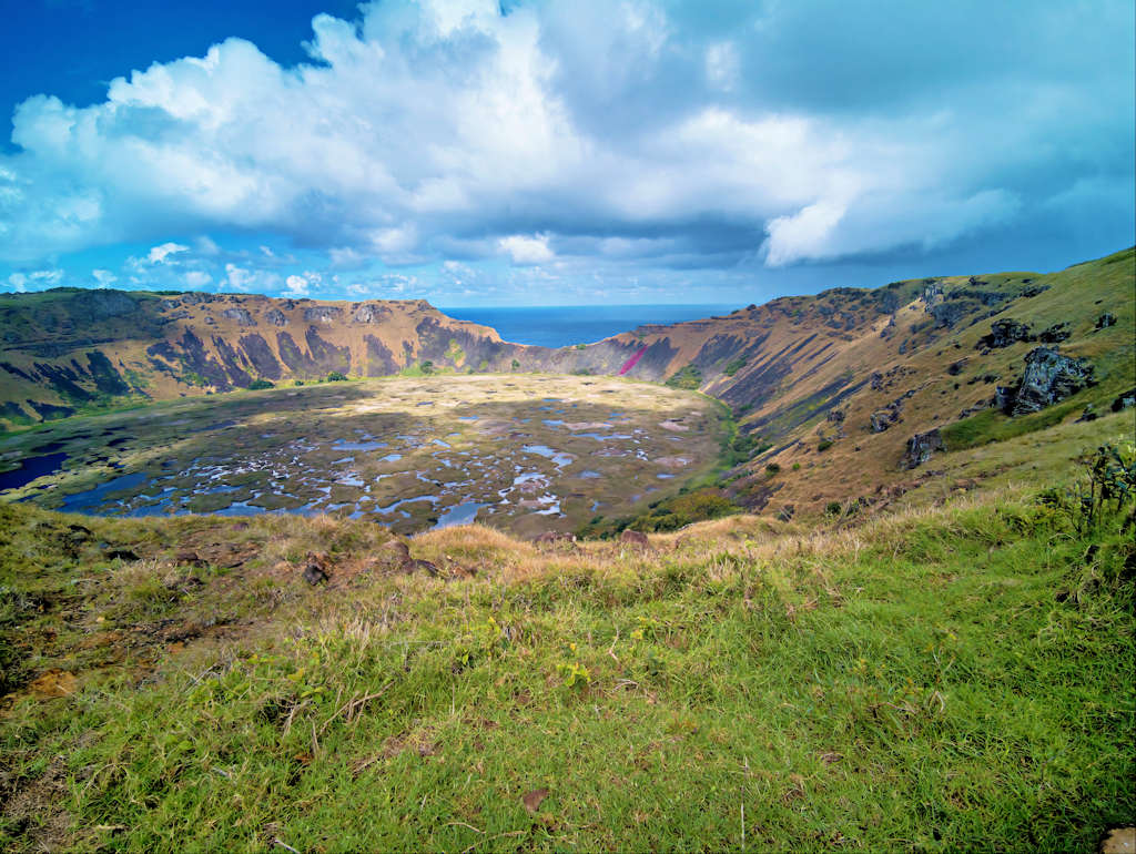
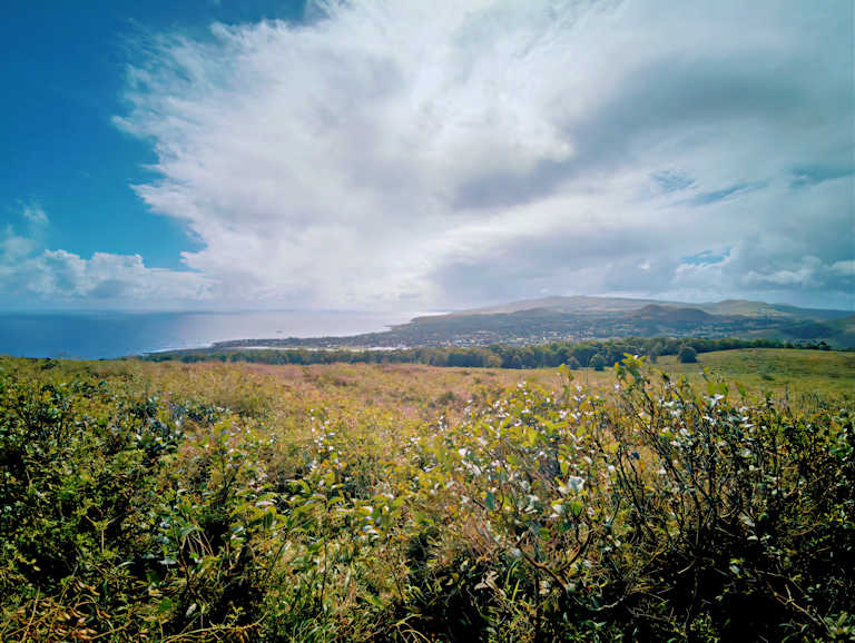
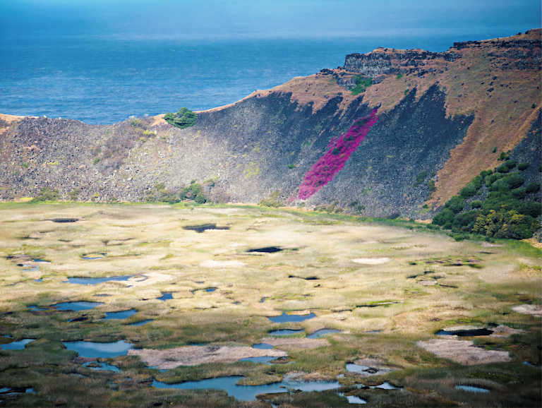
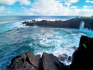
- Rano Kau is an extinct volcano that dominates the southwestern headland of Easter Island and is a part of the UNESCO World Heritage Site. Rano Kau is one of the three principal volcanic cones (along with Terevaka and Poike) whose lava flows merged over millions of years to form the characteristic triangular shape of Easter Island. It is one of the most striking geological features on Easter Island, Rano Kau is estimated to have formed about 2.5 million years ago. Its basaltic lava flows are some of the island’s oldest, with the youngest rocks dated between 150,000 and 210,000 years ago. The volcano features a large, almost perfectly conical caldera (crater) that is about 1.5 kilometers wide.
- The crater holds a beautiful freshwater lake covered by mats of totora reeds. This water source was historically one of the most important on the island, as Rapa Nui has no permanent rivers or streams. The crater comprises a unique ecosystem of both flora and fauna. The presence of a freshwater lake at the bottom of the crater contributes to its vibrant biodiversity, offering a habitat for various species of birds and plant life, some of which are endemic to the island. The geological history of Rano Kau involves a complex interplay of volcanic activity, erosion, and sedimentation that has led to the formation of its distinctive landscape.
- My intention was to walk the entire length of the crater rim. On the map, a path appeared to exist. The path was overgrown with vegetation, but it seemed possible to follow. Short time after I started a storm with torrential rain developed. As at that point I was at the farthest point away from my base and the extent of the storm was impossible to guess I decided to turn around.
- The torrential rain lasted for a few more hours, the time it took me to reach town. I stopped at a place I knew had fish soup. Taking off wet layers and enjoying an amazing hot fish soup was “something to remember”!
- As a natural wonder, Rano Kau not only showcases the geologic forces that shaped Easter Island but also holds significant cultural value for the Rapa Nui people. The crater is closely linked to their spiritual beliefs and practices. It is believed that Rano Kau served as a ceremonial site, with the prominent platform ‘Ahu Akivi’ located nearby. This platform is integral to Rapa Nui mythology and represents the collective memories and religious practices of its people. The gatherings held on the slopes of Rano Kau fostered communal interaction, enabling the Rapa Nui to reinforce social bonds while participating in essential cultural rituals.
- Located on the narrow crater rim overlooking the ocean and the motus (islets), the ceremonial village of Orongo is Rano Kau’s principal archaeological site. This was the location of the annual Tangata Manu (Birdman) cult and competition. There is a separate video on this site showing the Orongo village.
Hanga Roa and Rano Kau: Economic Landscape
- The economic landscape of Hanga Roa, the main town of Easter Island, is closely tied to its natural resources and unique cultural heritage of the region. The local economy significantly depends on tourism, driven by the island’s historical landmarks, such as the famous Moai statues, and the striking beauty of natural features like the Rano Kau crater. Tourists flock to the island for its rich Polynesian culture, offering a crucial source of income for residents. Tourism accounts for approximately 70% of Hanga Roa’s revenue, highlighting its prominence in sustaining the local economy.
- Fishing also plays a vital role in Hanga Roa’s economic framework. The surrounding waters are rich in marine life, providing fresh seafood for both local consumption and export. Traditional fishing practices, alongside sustainable fishing initiatives, bolster the community’s food security while preserving cultural traditions.
Hanga Roa: Practical Considerations
- All tourists to Easter Island must buy a National Park ticket before arriving on the island. All tourists intending to visit Easter Island must have a pre-booked round trip ticket. Before you are allowed to embark on a flight to Easter Island, you must provide proof of booked hotel/guesthouse accommodations.
- Most of Hanga Roa is covered by an LTE phone signal, however that signal almost never connects to the Internet. The phone and SMS connection is entirely random, the phone is most of the time useless on the island, unless you are on someone’s Wi-Fi. While I was visiting there, the island experienced an island-wide power outage of about half a day.
- Be careful in any “official” dealings you may have with anyone holding any administrative or legal power over you in Easter Island. I am not sure if this is a delayed result of decades of abusive past dictatorships that spill into today’s attitudes or a result of bitter resentments for the fact that the ancient culture of Easter Island was dismantled by foreign influences. Avoid any confrontational situation with a local (even a very low admin level person) who yields some form of “authority” or “power”. Try to avoid being alone in such a situation.
Download full-size master image files
Please use our images!
Your purchase is important to us!
- The financial reward is important. The moral boost we receive when someone cares enough to click that “ADD TO CART” button: priceless! Thanks!
- You may use the downloaded images as wallpaper, in a slide show, or to supplement your collection of images from a location you care about. Other possible use cases: a research paper, newsletter or personal website.

- The size of our master photo files is no less than 7952 x 5304,.JPEG, with very light compression. The photos taken during a 360 degree shoot (featured on a blog page that includes a 360 degree video) are taken in RAW format, with a phone camera. The RAW file is “developed” and processed with advanced software, including increasing the resolution with AI and AI upscaling. The resulting large format file is then polished for its final creative look.
Conditions of use for downloaded images:
- Downloading an image at listed price does not provide ownership of the image (we retain copyright). It provides a license for limited use and distribution of the downloaded image.
- Distribution is limited to 50,000 exposures or copies and for projects with a total budget of $5,000 or less. No billboards or magazine covers.
- May be used only with attribution as follows:
-
- © Photography by Cristian Coban, visit
whatsitliketovisit.com
- Any image or video purchased or copied from our website may NOT be used for resale, download or redownload, distribution or redistribution, or any other further commercial use.
- We accommodate larger projects and distribution at industry competitive rates. Please Contact us with details of your project and we will be happy provide a quote.