Walking in Salar de Atacama - The Atacama Salt Flats of the Atacama Desert, Chile - interactive 360-degree video
If you are viewing this on a mobile device, please turn to LANDSCAPE position. Drag the view on the screen with your finger (or move the device around) and you will see everything all around you – even what’s behind or on the ground. Viewing on a PC? Use the mouse to drag the view anywhere you want to see. If you have a VR viewer (goggles) you will be fully immersed. Better than IMAX! SUGGESTION: see the video again, change the viewing angles. You will discover new things!
IMPORTANT! Please click on the "Watch on YouTube" link for best viewing. The embedded small screen is inadequate for interactive 360 degree videos.
To see the same video in conventional screen format (non 360-degree video)
click here
360 preference survey
- If you’d like to research or purchase a 360-degree camera, here’s a link to a 360-degree camera like the one I used to produce my videos. I have nothing but good things to say about my camera (which I purchased from the same website as the link above).
Visiting Salar de Atacama
- If you are wondering: What’s it like to visit Salar de Atacama (the Atacama Salt Flats)?, you came to the right place. It is a visit in an area that has remained exactly the same whether you are visiting today, 1,000 years ago, 100,000 years ago or 1 million years ago. It is one of the very few places on Earth that has not changed its look and its properties significantly for millions of years! Creation of the flats began tens or hundreds of million years ago. By 10 million years ago, things stabilized and started looking significantly the same as they appear today. If walking on a surface that looks today the same as it looked 1 million years ago does not put a chill in your spine, few things will.
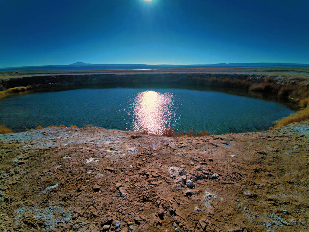
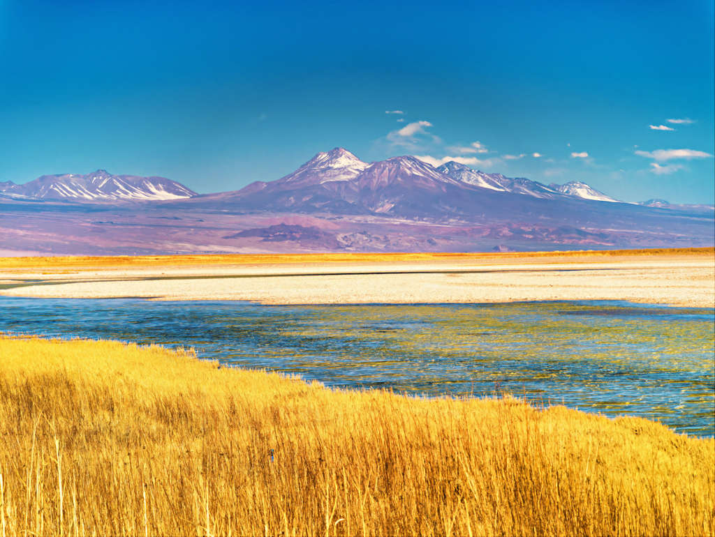
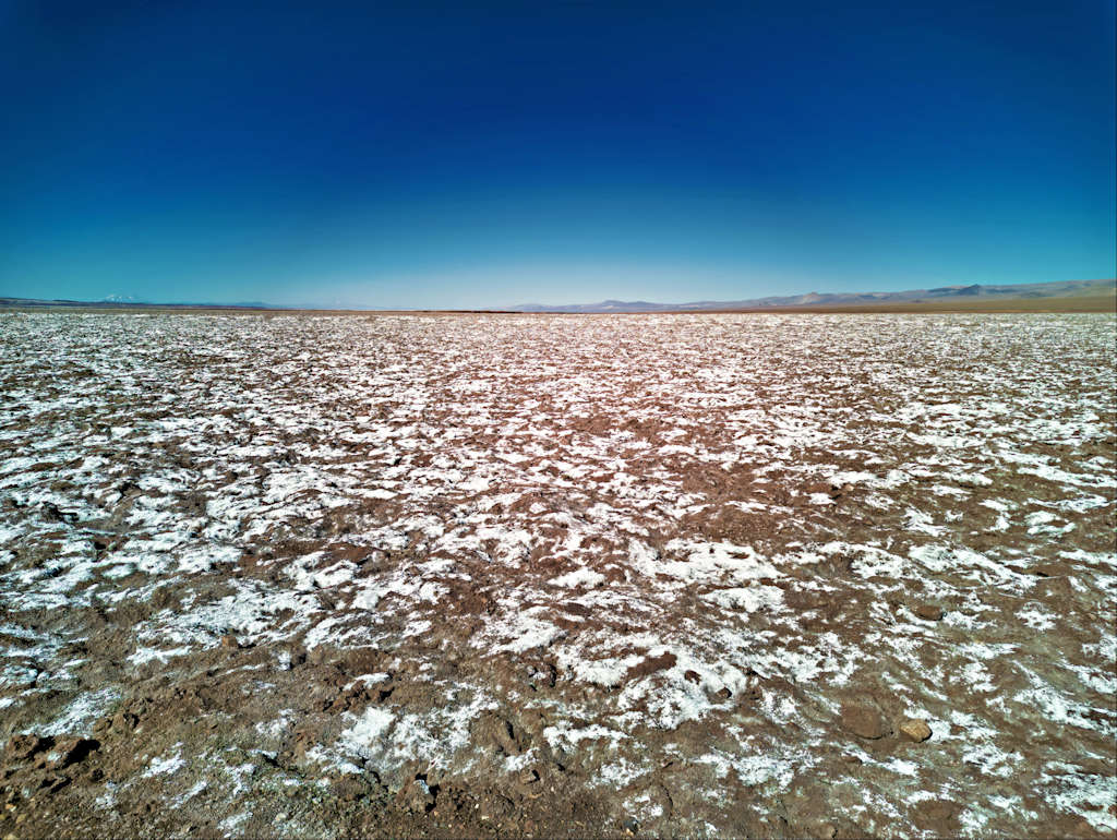
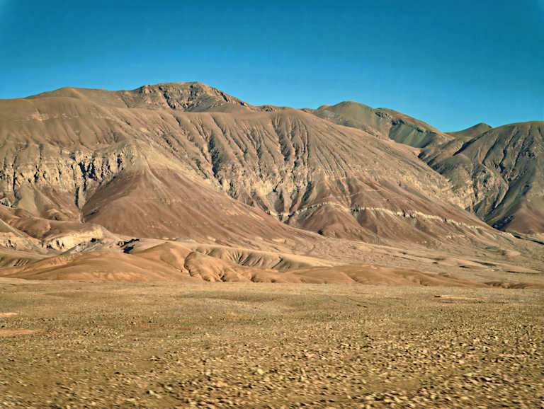
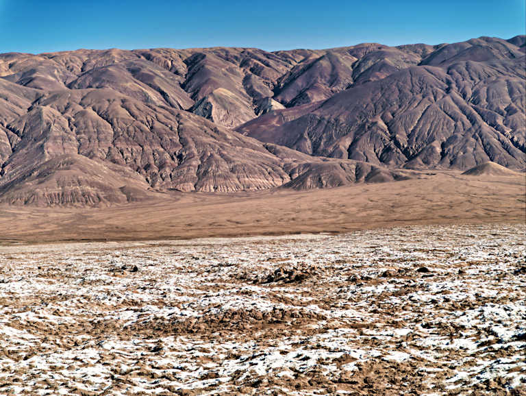
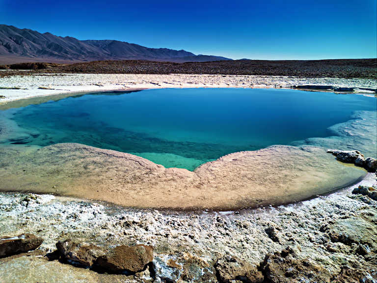
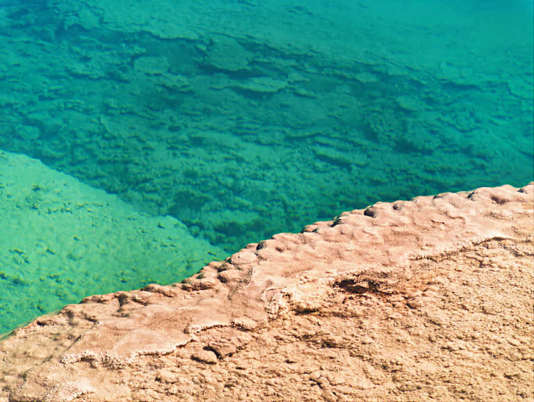
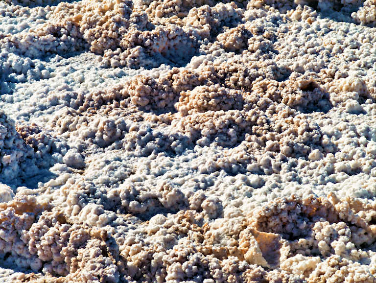
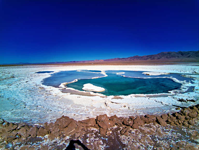
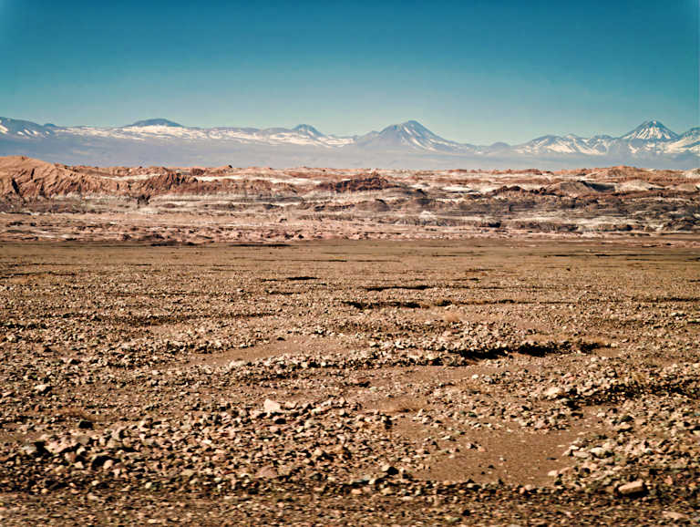
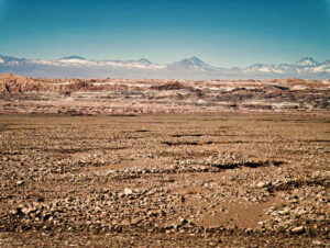
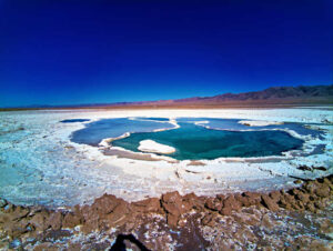
- The majesty is in the details. You need to know where to look and what to look for. On a “Macro” level, look at the vast mountain ranges that surround this vast area (over 3,000 square kilometers), which can be seen in the distance in all directions. Look at the vast plateau you are walking on, as flat as it can be, but situated at 2,300 meters (about 7,500 feet) above sea level. On a “Micro level”, look at the ground. In some places, it is pure white salt. In other places it is a jumble of other-worldly looking solidified minerals. How all this formed and why it is unique is explained in the words below. Then look at the beautiful lakes that reflect the sunlight and the sky in colors that seem unnatural, yet they are absolutely natural, as they have been for hundreds of millenia!
Geologic History and Formation
- Salar de Atacama is a vast endorheic basin, meaning it is a closed drainage system with no outflow to the sea. It is bordered by the dramatic peaks of the Andes Mountains to the east, including several large volcanoes (such as Licancabur), and the Cordillera de Domeyko to the west.
- It is the largest salt flat in Chile and the third-largest salt flat in the world, renowned for its extreme aridity, unique geology, and vast mineral deposits, particularly lithium. Located in the heart of the hyper-arid Atacama Desert in northern Chile, it is a place of significant ecological, industrial, and scientific importance. The area encompasses a unique landscape characterized by its stunning white crust of salt, contrasting sharply with the deep blue skies above. The natural beauty of the salar is accentuated by its proximity to majestic mountains and volcanic formations, further highlighting the geographical diversity of this extraordinary region.
- The Salar de Atacama is situated within a larger, subsiding sedimentary basin, known as “La gran fosa” (the great trench). This depression is a topographical anomaly thought to be caused by a dense rocky block remaining at a lower position than the rest of the Andes. The basin is bounded by north-south geological structures. Water from surrounding streams, which originate from the Andes, flows into the basin. Due to the closed nature of the salar, this water has no outlet and is lost only through evaporation.
- The region is characterized by an extremely arid climate, with an average annual rainfall of less than 30 millimeters (under 1.2 inches) per year. The high surrounding mountain ranges create a strong rain shadow effect, contributing to its status as one of the driest places on Earth. This low precipitation and high evaporation rate (around 3,500 mm per year) are crucial factors in the formation and composition of the salt flat. Please note that the average rainfall is 30 millimeters per year, while the evaporation rate is about 100 times higher!
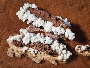
- Over millions of years, as the water evaporated in the hyper-arid conditions, dissolved minerals and salts were left behind, forming the massive salt crusts and subterranean brines. The accumulation of the halite (rock salt) body is estimated to have begun within the last 10 million years.
Atacama Salt Flats (Salar de Atacama) unique characteristics
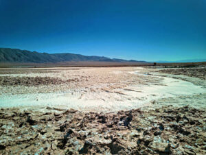
- Unlike other major salt flats (like Salar de Uyuni) which are often smooth and periodically covered with shallow water, the core of the Salar de Atacama exhibits a high level of roughness. This is the result of continuous evaporation and the absence of temporary surface water to smooth it out. The surface is primarily composed of hard crusts of sodium chloride, with a perimeter of clay and carbonate-rich material.
- This geological process has not only created a visually striking environment but has also resulted in the accumulation of valuable minerals such as lithium and potassium. The Salar de Atacama is one of the world’s most significant sources of several valuable minerals.
- Lithium (Li): The brines have one of the highest lithium concentrations of any salt flat in the “Lithium Triangle” (Chile, Argentina, and Bolivia), reaching concentrations that can exceed 2,700 parts per million (ppm) and even up to 5,000 mg/L in some sectors. The lithium reserves in Salar de Atacama are estimated at around 7.5 million metric tons. The combination of high lithium concentration, a high rate of evaporation, and extremely low rainfall makes the production of lithium carbonate easier and cheaper here than in many neighboring salars. This makes the Salar de Atacama a critical global source for lithium, which is essential for manufacturing rechargeable batteries used in electric vehicles, smartphones, and laptops. The high industrial demand has made lithium mining a major activity in the region.
- The area is also rich in Potassium (K). Estimates suggest that Salar de Atacama contains approximately 3 million metric tons of potassium chloride. There is also Magnesium (Mg) and Boron (B).

Scientific Uniqueness and Importance
- The Atacama Salt Flats are home to a variety of ecosystems, including unique flora and fauna adapted to the harsh desert conditions. There are populations of flamingos, which can be observed feeding in the the lagoons like Laguna Chaxa. Salar de Atacama are a part of the Los Flamencos National Reserve and provide a critical habitat for various species of Andean flamingos. These birds feed on the microorganisms and algae that thrive in the saline waters, making the salar an important site for ornithology and conservation.
- Unique Halophilic Life. The highly saline waters and rock salt environments host specialized, salt-loving microorganisms (halophiles) that can survive in conditions similar to what might have existed on early Earth or other planetary bodies, offering insights into the limits of life. The extreme aridity and high UV radiation mimic conditions found on Mars, leading to the Atacama Desert being used by NASA for testing equipment designed to search for life on other planets.
- You can see from the above the potential of conflict between our human desires: the desire for “more”-“more”-“more” (minerals, cars, conveniences) and our desire to preserve life on planet Earth. I am very worried that this immense area will become a vast open-pit environment-destroying mining operation. I am worried that Flamingos and tourists will be replaced by huge trucks and “forbidden” private roads.
Visiting Salar de Atacama: Practical Information
- The salt flats are conveniently located near the small town of San Pedro de Atacama, approximately 50 kilometers away. Visitors can access the Salar either by renting a vehicle or joining a guided tour, both of which offer unique opportunities to appreciate the breathtaking landscapes. Renting a vehicle gives you the freedom to explore at your own pace, while guided tours typically provide in-depth knowledge about the ecological and geological significance of the salt flats.
- As for entrance fees, accessing the Salar de Atacama generally requires a small fee that can vary depending on the tour operator or the specific areas of the salt flat you wish to visit. It is advisable to check with your guide or rental service beforehand to avoid any unexpected costs. Most tours operate daily, but it is wise to book in advance, especially during peak tourist seasons, which typically occur from June to August.
- Visitors are usually allowed to swim, but only in designated areas. There are strict limits on the number of people in the water at any time. There is a time limit for the amount of time any person is allowed to remain in the water. When I visited, the maximum time in the water was 20 minutes. In the winter, the water temperature is only a couple degrees over freezing. On the way out, there are showers so you can remove the salt from your skin. But get this (and it is not a joke): your rinsing shower is timed by an attendant and is limited to… 30 seconds. Remember, though, you are in the driest place on Earth, so water is a most precious commodity!
- The optimal time to visit Salar de Atacama is during the early morning or late afternoon. These times of day not only provide the most beautiful light for photography but also help you avoid the intense midday heat. Furthermore, note that the access to water in and around the salt flats is regulated to preserve this fragile ecosystem. Visitors should carry sufficient water during their stay, as natural water sources are scarce, and it is essential to follow safety guidelines to ensure a responsible interaction with the environment.

Download full-size master image files
Please use our images!
Your purchase is important to us!
- The financial reward is important. The moral boost we receive when someone cares enough to click that “ADD TO CART” button: priceless! Thanks!
- You may use the downloaded images as wallpaper, in a slide show, or to supplement your collection of images from a location you care about. Other possible use cases: a research paper, newsletter or personal website.
- The size of our master photo files is no less than 7952 x 5304,.JPEG, with very light compression. The photos taken during a 360 degree shoot (featured on a blog page that includes a 360 degree video) are taken in RAW format, with a phone camera. The RAW file is “developed” and processed with advanced software, including increasing the resolution with AI and AI upscaling. The resulting large format file is then polished for its final creative look.
Conditions of use for downloaded images:
- Downloading an image at listed price does not provide ownership of the image (we retain copyright). It provides a license for limited use and distribution of the downloaded image.
- Distribution is limited to 50,000 exposures or copies and for projects with a total budget of $5,000 or less. No billboards or magazine covers.
- May be used only with attribution as follows:
-
- © Photography by Cristian Coban, visit
whatsitliketovisit.com
- Any image or video purchased or copied from our website may NOT be used for resale, download or redownload, distribution or redistribution, or any other further commercial use.
- We accommodate larger projects and distribution at industry competitive rates. Please Contact us with details of your project and we will be happy provide a quote.